Tropical storm Fiona forecast & US landfall potential uncertainty rises
With recent forecast model runs it appears the uncertainty over where tropical storm Fiona heads over the next week has risen, with more models showing a closer path to the United States, and fewer preferring the track through the Atlantic near Bermuda.
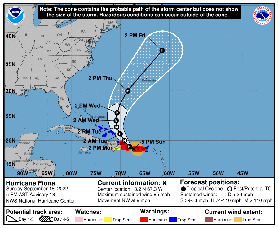
Update, Sunday 18th September: Fiona has now intensified into a Category 1 hurricane, with sustained winds of 80 mph on approach to Puerto Rico and the Dominican Republic. As well as hurricane force winds, 12 inches or more of rainfall are forecast with a threat of severe flooding and landslides. The uncertainty over the forward track has lessened, with the consensus continuing to move towards hurricane Fiona heading north into the Atlantic, where Bermuda will be in the cone and a close watch on Fiona will be needed as the storm approaches, perhaps at major hurricane strength at that stage.
As we reported yesterday, Tropical storm Fiona formed in the Atlantic, becoming the sixth named storm of this still relatively quiet 2022 hurricane season.
The forecast models showed storm Fiona taking a path through the northern Caribbean islands, but with some uncertainty in the cone over the eventual direction storm Fiona would choose to take.
The uncertainty has risen with recent forecast model runs today, with a significant spread in outcomes, ranging from a southerly track into the Gulf of Mexico and intensification there before a US landfall, to the same track up the middle of the Atlantic putting Bermuda at-risk before then heading to Europe as an extratropical storm.
Between these two extremes, the models still show closer passes to Florida, as well as strong landfalls on the US southeast coast, around Georgia or South Carolina.
So the spread is particularly wide still.
Which you can see in the NHC forecast cone, for tropical storm Fiona below:
Land interaction is set to have a significant bearing on where tropical storm Fiona heads after the weekend.
A more significant interaction with Hispaniola could weaken Fiona and the models favour a more southerly track in that case, with tropical storm Fiona heading for anywhere from the Gulf to US eastern seaboard (with Florida in between).
Less interaction and a generally stronger scenario might see Fiona heading further north, with the curve into the Atlantic and strengthening there.
One point that is important to note is that many of these scenarios do feature strengthening in the future for Fiona, with a hurricane deemed possible by the models.
At the same time, tropical storm Fiona remains relatively unstructured so far, as cyclones go, so could the Hispaniola impact degrade her further? Time will tell.
The insurance, reinsurance and insurance-linked securities (ILS) industry may need to continue watching this storm closely for four or five days more before certainty in the forecast path becomes more assured, it seems.
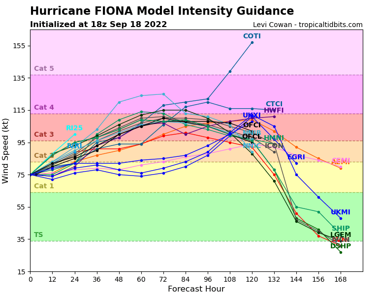
At this stage it’s perhaps worth looking at intensity guidance from the models, rather than directional tracks, as it shows the land interaction the models currently expect (the dip), as well as the fact many favour a stronger, hurricane Fiona outcome 100 hours or so out.
The below is from TropicalTidbits.com:
A number of models spin Fiona up the Atlantic closer to the US, with the potential for higher pressure to then push the storm or hurricane left again, with a possible landfall on the eastern seaboard as a hurricane, or strong storm.
One scenario can be seen below in a recent model run posted on Twitter by a meteorologist:
Latest Euro model has Fiona hitting a brick wall AKA high pressure & getting pushed back closer to land about 10 days from now. Too early to determine exactly where this system is headed, but it bears watching. Track will continue to shift back and forth#wxtwitter #ncwx #fiona pic.twitter.com/nYxcJyyBfX
— WRAL Anthony Baglione (@wx_anthony) September 16, 2022
So, for now, insurance, reinsurance and ILS market interests need to keep on-watch for storm Fiona, as it’s impossible to predict the outcome at this stage.
Certainty may increase through the weekend, but it’s also possible we may not have a very clear idea until early next week, so we’ll update you should the threat persist into Tuesday.
On that note, we’ll be observing the bank holiday in the UK on Monday, but should anything really threatening for insurance and reinsurance interests emerge, we may post a brief update that day.
Track the 2022 Atlantic tropical storm and hurricane season on our dedicated page and we’ll update you as new information emerges.