Tropical storm Debby forecast for hurricane strength landfall in Florida
Tropical storm Debby has become the fourth named storm of the 2024 Atlantic hurricane season, with forecasts predicting intensification while over the Gulf of Mexico and that a hurricane Debby landfall is now expected for Florida.
Meteorologists had been watching Invest 97L for a number of days now and forecast model runs showed a strong chance for it to achieve tropical storm status and be named as Debby. However there was initially some uncertainty over its track, but that has now become clearer since its upgrade to tropical storm status.
The storm has now officially been named Debby and most forecasters are expecting it to make low category hurricane status by landfall in Florida’s Big Bend region.
Currently, tropical storm Debby has 50 mph sustained winds and stronger gusts, but it is moving over very warm water in the Gulf of Mexico so some intensification is anticipated.
Limiting that is partly the large size of Debby, but also the storm has a relatively small core, as well as the limited time it has to spend over the Gulf before land interaction begins.
The National Hurricane Center (NHC) has said in its latest update, “Debby is moving toward the north-northwest near 13 mph (20 km/h). A turn toward the north is expected later today, followed by a slower motion toward the northeast on Monday and Tuesday. On the forecast track, the center will move across the eastern Gulf of Mexico through tonight and reach the Florida Big Bend coast Monday morning. Debby is then expected to move slowly across northern Florida and southern Georgia Monday and Tuesday.
“Maximum sustained winds have increased to near 50 mph (85 km/h) with higher gusts. Continued strengthening is forecast, and Debby is expected to become a hurricane by tonight before it reaches the Florida Big Bend coast. Weakening is expected on Monday and Tuesday after Debby moves inland.”
Forecasters say conditions will remain conducive for development and intensification as tropical storm Debby moves north, then curves in towards the Florida Big Bend area of the Panhandle.
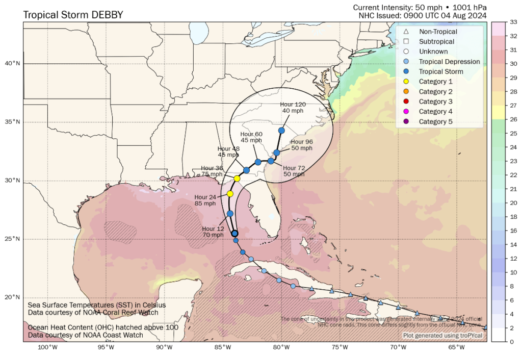
The image below from Tomer Burg’s excellent weather resources shows the forecast path and cone of uncertainty, as well as wind intensity forecasts:
The forecast now predicts hurricane Debby could reach sustained winds of around 85 mph before landfall as it passes over very warm Gulf waters, before making landfall as a mid-strength category 1 storm and then weakening.
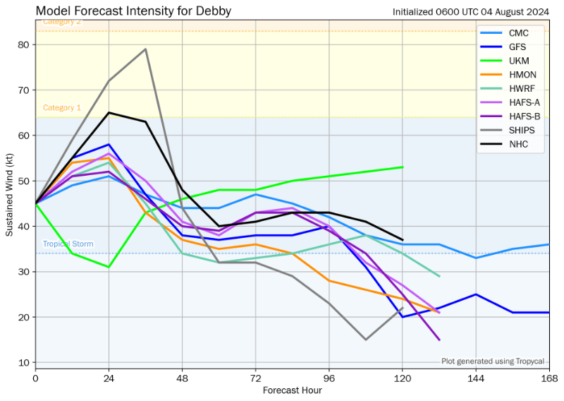
The model intensity guidance below (also from Tomer Burg’s resources) shows most still opting for a relatively strong tropical storm Debby landfall and still only a few for Debby to attain hurricane status at this time, which reflects continued uncertainty.
But some meteorologists also warn of a chance of rapid intensification, with only Debby’s size, relatively short time left over the Gulf and land interaction stopping it becoming a much more impactful landfall.
Forecasters continue to warn that Debby will pick up a lot of moisture as it moves towards Florida and the south eastern United States, with some cautioning that flooding could be a concern no matter how strong the winds from tropical storm Debby become.
The NHC said, “Tropical Storm Debby is expected to produce rainfall totals of 6 to 12 inches, with maximum amounts of 18 inches, across portions of northern Florida through Friday morning. This rainfall will likely result in areas of considerable flash and urban flooding, with significant river flooding expected.”
As ever with a hurricane heading for the Florida Panhandle, storm surge is also a concern as water can build-up more significantly due to the curvature of the coastline there.
The NHC currently forecasts storm surge heights of as much as 6 to 10 feet for Suwannee River to Aucilla River in Florida, with a much wider area seeing surge of 4 to 6 feet and even Tampa Bay expected to see 2 to 4 feet of storm surge.
At the moment, the forecast area of landfall is relatively sparsely populated, but any shift to the west in the track could bring Debby closer to Tallahassee, which is the largest population centre in that region of Florida.
Some models continue to show Debby crossing land and emerging into the Atlantic, after which a second landfall is seen as possible around the Carolinas, where tropical storm Debby could again be strengthening and the rainfall threat is expected to remain significant as well, with more time off the East coast to pick up additional moisture.
There remains some uncertainty over the landfall strength, the track and further out how Debby could behave if it makes it back into the Atlantic, so this storm is still something for the insurance, reinsurance, catastrophe bond and insurance-linked securities (ILS) markets to track this weekend.
Catastrophe bond fund manager Icosa Investments AG commented on the potential for storm Debby development on Friday, saying it is tracking the system closely, as other cat bond and ILS fund managers will be.
Icosa Investments said, “While forecasts vary regarding its path, the general consensus is that the system will approach Florida from the western coast (possibly near Tampa), cross the Floridian peninsula, and then move back into the Atlantic before moving Northeast.
“Most intensity forecasts do not anticipate for the system to reach hurricane strength. However, given the warm sea surface temperatures and low wind shear, there’s still a small possibility that models underestimate the potential for intensification, similar to what occurred with Hurricane Beryl recently. Fortunately, the system’s current lack of organisation limits the time available for significant strengthening before it makes landfall.
“At this point, we do not expect any impact on cat bond investors, even though a Category 1 hurricane could still cause billions of insured losses if it directly hits the densely populated Tampa area. Such an event might result in some attachment erosion, but is unlikely to result in significant outright losses in the cat bond market. There is also some uncertainty regarding the storm’s path after it reemerges into the Atlantic, with potential impacts in North Carolina — a region well-represented in the cat bond market — still possible.”
You can track this and every Atlantic hurricane season development using the tracking map and information on our dedicated page.