Tropical storm Alberto kicks off 2024 Atlantic season
The 2024 Atlantic hurricane season is underway with the first named tropical storm, Alberto, having formed today, as a low pressure system in the Gulf of Mexico gains more structure and is now expected to head for Mexico bringing torrential rains and a warning of flooding.
While the forecasts for the 2024 hurricane season have been for particularly high numbers of storms, it’s taken until June 19th for one to actually be named, which is considered a relatively slow start (given those forecasts).
While tropical storm Alberto is expected to strengthen a little, given its location and the fact it is heading for a relatively quick landfall in Mexico’s Gulf coast, there is little threat to the United States aside from rains that could spread north into Texas.
As a result, there is not expected to be a significant threat of insured losses with tropical storm Alberto, although the torrential rains heading for Mexico could present a threat to property, livelihoods and lives.
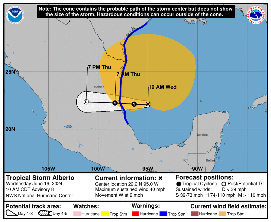
You can see tropical storm Alberto’s position and forecast path below:
The National Hurricane Center (NHC) states that tropical storm Alberto has 40 mph winds and that some slight strengthening is forecast today or tonight before the center of Alberto reaches land in northeastern Mexico.
The NHC warned that, “Tropical Storm Alberto is expected to produce rainfall totals of 5 to 10 inches across northeast Mexico into South Texas. Maximum totals around 20 inches are possible across the higher terrain of the Mexican states of Coahuila, Nuevo Leon, and Tamaulipas. This rainfall will likely produce considerable flash and urban flooding along with new and renewed river flooding. Mudslides are also possible in areas of higher terrain across northeast Mexico.”
The NHC also warns of the potential for a small storm surge, as follows:
– Sargent, TX to Sabine Pass, TX…2-4 ft
– Galveston Bay…2-4 ft
– Mouth of the Rio Grande, TX to Sargent, TX…1-3 ft
– Sabine Pass, TX to Vermilion/Cameron Parish Line, LA…1-3 ft
At those surge levels inundation would be expected to be minor, to non-existent except for in particularly low-lying waterfront areas.
The slower the start to the season, the more frequent the storm formation and activity we might expect to see in the peak of the hurricane season, which could lead to more challenges for those tracking and analysing storms for their potential impacts on portfolios of insurance and reinsurance risks.
While we’re highlighting this first storm of the season in an article, we’re unlikely to cover them all through the months ahead and will only provide coverage where impacts are seen as possible that could threaten insurance and reinsurance, as well as catastrophe bond or ILS, market losses.
But you can always keep track of the 2024 Atlantic tropical storm and hurricane season on our dedicated page and we’ll update you as new information on any specific threats emerge.