Hurricane Milton: Forecast models converge on Tampa Bay, surge height indications rise

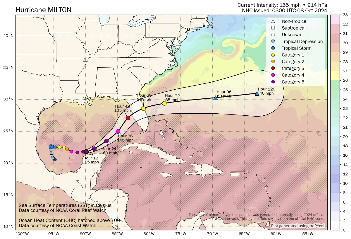
Overnight, hurricane Milton’s intensity peaked at sustained winds of 180 mph with a central pressure of 897 mb before an eyewall replacement cycle began. While the storm has weakened somewhat to a Category 4 with 155 mph winds now, the threat to Florida should not be understated and storm surge height indications for Tampa Bay are now at between 10 to 15 feet.
In its latest update this morning, the NHC warns of “destructive storm surge”, “devastating” and “life-threatening” winds with a portion of the entire Florida Peninsula exposed to hurricane Milton.
Milton is now expected to grow in size on approach to Florida’s west coast, with most forecast models continuing to converge their tracks on or around the Tampa Bay area, this remains an event of particular concern for those in its path, as well as for interests in the insurance, reinsurance, catastrophe bond and insurance-linked securities (ILS) industry.
Models appear to be converging on the Tampa Bay region, but it’s important to note that a difference at landfall of a few miles north or south of the bay area can make a huge difference to eventual impacts, especially for storm surge heights.
You can see the latest model runs below from Tomer Burg:
Uncertainty remains high and the range of potential insurance, reinsurance and ILS market losses is therefore high as well.
Dependent on landfall location, intensity and the size hurricane Milton grows to, our sources continue to discuss figures from as low as $10 billion right the way up to $100 billion and beyond, based on stochastic scenarios.
It is abundantly clear that, hurricane Milton threatens potentially tens of billions of dollars of insured losses, if the forecasts prove to be correct.
With every passing hour, as Milton heads towards Florida, the chances of the models proving to be incorrect reduces.
Right now, most models take hurricane Milton near or into Tampa Bay, with the NHC indicating sustained winds of between 125 mph and 130 mph with gusts of over 155 mph prior to landfall, the storm could still be at major Category 3 strength or higher when it makes landfall.
The latest forecast cone and wind speed indications are below, also from Tomer Burg:
That will result in “potentially devastating” hurricane force winds for some of the Florida coastline, but the NHC also says Milton is forecast to remain a hurricane as it crosses Florida, so bringing damaging winds inland and the i4 corridor towards Orlando is not out of the questions as a track for Milton inland.
Heavy rainfall is already hitting Florida and expected to continue with as much as 15 inches expected even before hurricane Milton arrives, after which Milton is then set to bring inches more rain and exacerbate flooding.
While wind and rain related damage is already looking set to be significant with Milton, it is the storm surge impacts that have emergence management teams particularly concerned.
As we reported yesterday, hurricane Milton’s storm surge heights for Tampa Bay were being indicated at between 8 and 12 feet, which is sufficient to be catastrophic for the city and region.
Now though, the NHC has raised the surge height indications for the entire western coast of Florida, with now between 10 and 15 feet anticipated for Tampa Bay and surrounds, a truly historic surge that would break all recorded records there.
Most concerning about the map below from the NHC is not just the peak surge height indications that suggest historic amounts of water will pile into Tampa Bay, but also the fact the surge heights for the entire most inhabited and exposure loaded region of the western coast of Florida are sufficient to cause significant impacts and losses.
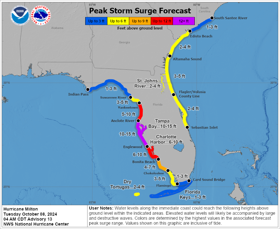
The NHC comments, “Milton is expected to grow in size and remain an extremely dangerous hurricane when it approaches the west coast of Florida on Wednesday. A large area of destructive storm surge will occur along parts of the west coast of Florida on Wednesday. This is an extremely life-threatening situation and residents in those areas should follow advice given by local officials and evacuate immediately if told to do so.”
Hurricane Milton is expected to turn to the northeast and head for Florida having skirted the Yucatan but failed to get close enough for it to seriously degrade the storm’s progress, or to trigger the Mexico catastrophe bond we now believe.
Milton is forecast to approach the west coast of Florida, likely still as a major hurricane, with landfall now expected to be late Wednesday or into Wednesday night local time.
The NHC said that, “While fluctuations in intensity are expected, Milton is forecast to remain an extremely dangerous hurricane through landfall in Florida.”
There is no change to the outlook that hurricane Milton is the biggest test for the reinsurance, catastrophe bond and ILS market since 2022’s hurricane Ian.
However, model scenarios suggest Milton could be a more significant loss, if it makes landfall in the worst area close to Tampa Bay.
As we said though, there remains great uncertainty still and a wide spread of stochastic loss indications coming out of modelling firms for hurricane Milton, with still anything from $10 billion up to more eye-watering loss levels seen as potential outcomes, depending on the precise landfall location, intensity and importantly the surge impacts for Tampa Bay.
You can track this and every Atlantic hurricane season development using the tracking map and information on our dedicated page.
Also read:
– Hurricane Milton losses could amount to tens of billions, but uncertainty high: BMS’ Siffert.
– As hurricane Milton intensifies, Mexico’s catastrophe bond comes into focus.
– Material hurricane Milton losses could change 2025 property reinsurance price trajectory: KBW.
– Cat bond & ILS managers explore options to free cash, as hurricane Milton approaches.
– Hurricane Milton: First Tampa Bay storm surge indications 8 to 12 feet.
– Hurricane Milton is biggest potential ILS market threat since Ian in 2022: Steiger, Icosa.
– Hurricane Milton forecast for costly Florida landfall. Cat bond & ILS market on watch.