Hurricane Francine likely today, strengthening forecast up to Louisiana landfall on Wednesday
The sixth named tropical storm of the 2024 Atlantic hurricane season was named yesterday, as tropical storm Francine formed in the Gulf of Mexico. Today, we are expected to see hurricane Francine, as the storm wins the battle against shear and dry air and heads for the central Louisiana coast while strengthening.
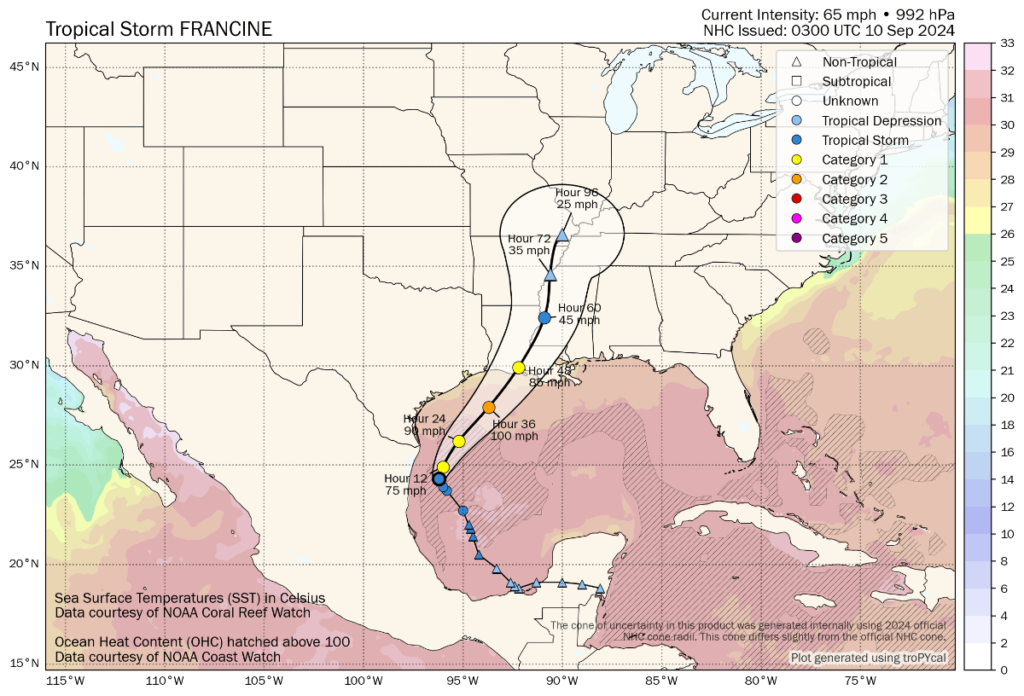
Tropical storm Francine currently has 65 mph sustained winds and higher gusts, while the forecast is for additional intensification over the day or two and for landfall within 48 hours.
Francine has been struggling to gain structure due to entrained dry air and some wind shear. But this battle appears to be being won by the storm and a hurricane is now forecast, while the National Hurricane Center now warns of potentially significant strengthening ahead.
But the time it has taken Francine to strengthen so far, has lessened its potential intensity by the time it reaches the US Gulf coast and makes landfall, some meteorologists are suggesting. Although, given the warmth of Gulf waters, rapid intensification cannot be ruled out over the next day or so.
Late yesterday, new forecast data from the NHC had suggested that hurricane Francine would reach Category 2 with 100 mph sustained winds at landfall. But this morning, updated data again suggests sustained winds of just above 85 mph with gusts to 115 mph.
However, the Gulf of Mexico waters remain extremely warm, so there is ample fuel for hurricane Francine to intensify more rapidly, should it get the chance and some of the forecast models still opt for a more intense scenario, so Francine’s progress will need watching today.
The forecast cone of uncertainty is relatively wide still, narrowed slightly but covering a wide swathe of the Louisiana coastline.
However, data suggests the current landfall track is a relatively sparsely populated area, although some more populous towns and cities are inland of it.
The current forecast and NHC outlook continued to suggest that, while potentially impactful for the regions it impacts hardest, Francine may not be too much of a concern for reinsurance carriers and the insurance-linked securities (ILS) market, with the primary market likely to retain the largest share of any losses.
You can see the current location and forecast cone for tropical storm Francine below, from Tomer Burg’s website:
The NHC said this morning, “At 100 AM CDT (0600 UTC), the center of Tropical Storm Francine was located near latitude 24.3 North, longitude 96.3 West. Francine has moved little over the past few hours, but it is expected to resume a motion toward the north-northwest near 5 mph (7 km/h). A slow north-northwest motion is expected through this morning, followed by a turn to the northeast with an increase in forward speed. On the forecast track, Francine is anticipated to be just offshore of the coasts of northeastern Mexico and southern Texas through today, and make landfall in Louisiana on Wednesday.
“Maximum sustained winds remain near 65 mph (100 km/h) with higher gusts. Francine will likely become a hurricane today, with significant strengthening expected before it reaches the coast.”
Note the word significant there. The Gulf of Mexico waters remain very warm, so there is plenty of fuel for tropical storm Francine to become a hurricane today as forecast and intensify as it heads to Louisiana.
Which means the reinsurance, catastrophe bond and ILS market will still need to watch closely, in case more rapid than expected strengthening does occur.
You can track this and every Atlantic hurricane season development using the tracking map and information on our dedicated page.