Hurricane Francine heads for Louisiana landfall. Loss said likely above $1bn by Gallagher
Francine was upgraded to a hurricane last night and the sixth named storm of the 2024 Atlantic hurricane season has strengthened to sustained winds of 90 mph and now heads for landfall in Louisiana, where reinsurance broker Gallagher Re anticipates insured losses in the low single digit billions of dollars.
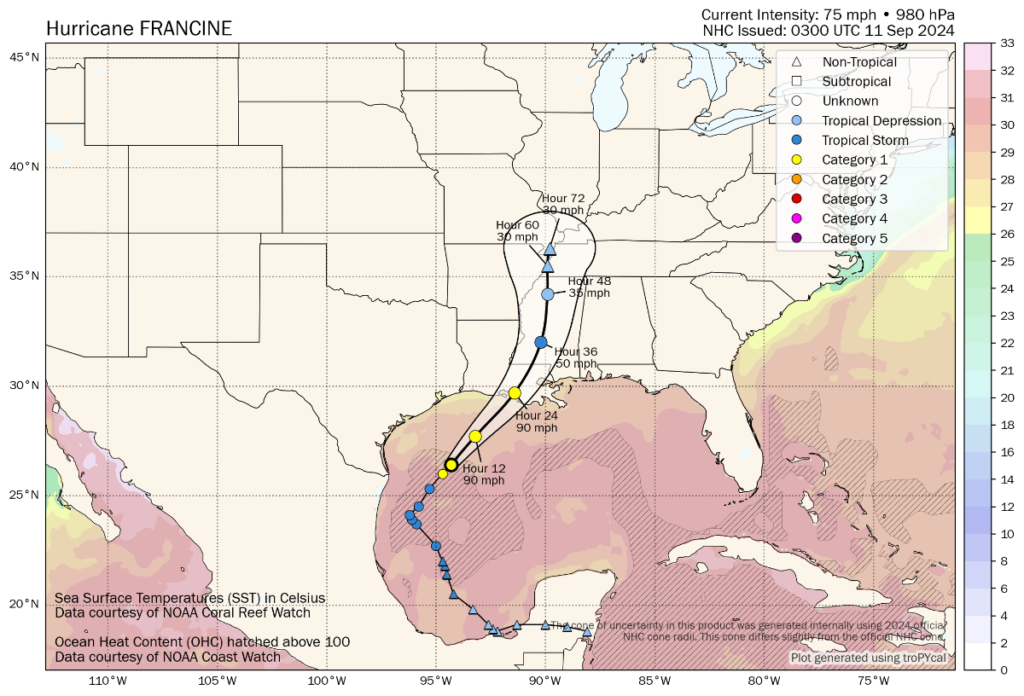
Hurricane Francine currently has 90 mph sustained winds and higher gusts, while the forecast is for some additional intensification over the final hours up to landfall which is expected later today.
Francine has been slower to gain structure than had originally expected as it battled dry air and wind shear, which has saved the Louisiana coast from a more impactful storm it now seems.
However, given the warmth of Gulf waters, intensification right up to landfall cannot be ruled out over the rest of today, before landfall is forecast for the central Louisiana coast later today.
The landfall region is low-lying, so storm surge exposed, but relatively sparsely populated, while further inland areas like Baton Rouge will be affected, but hurricane Francine is expected to weaken quickly once onshore.
Reinsurance broker Gallagher Re said, “Based on the current NHC forecast track and initial storm surge inundation / rainfall expectations, it would correlate with insured losses for the private insurance market likely exceeding USD1 billion. This would align with recent historical Category 1 landfalling storms in Louisiana.
“The overall expectation should Francine strike Louisiana as a strong Category 1 storm, is that insured losses would remain roughly in the ballpark of USD1 billion and be highly manageable for the re/insurance industry.”
The broker also cautioned, “Should Francine strengthen more than originally anticipated (current NHC landfall forecast: 90 mph; strong Category 1), then wind and water-related losses (private insurance market and NFIP) might result in notably higher estimates. Recent Category 2 storms in the state have recorded insured loss costs into the low or mid-single-digit billions (USD).”
It also seems possible, based on the latest forecast, that losses could end up below the billion dollar mark, if Francine fails to intensify much more.
The current forecast and NHC outlook still suggest that, while potentially impactful for the region around landfall, Francine is unlikely to be too much of a concern for reinsurance carriers and the insurance-linked securities (ILS) market, with the primary market likely to retain the largest share of its relatively low losses.
You can see the current location and forecast cone for tropical storm Francine below, from Tomer Burg’s website:
The NHC said this morning, “At 100 AM CDT (0600 UTC), the center of Hurricane Francine was located near latitude 26.6 North, longitude 94.1 West. Francine is moving toward the northeast near 10 mph (17 km/h). A faster northeastward motion is expected today, and Francine is anticipated to make landfall in Louisiana within the warning area this
afternoon or evening. After landfall, the center is expected to move northward into Mississippi tonight and Thursday.
“Data from the Air Force Hurricane Hunters indicate that maximum sustained winds have increased to near 90 mph (150 km/h) with higher gusts. Some additional strengthening is expected this morning. Francine is expected to weaken quickly after it moves inland.”
Hurricane Francine is forecast to bring total rainfall of 4 to 8 inches, with local amounts to 12 inches across eastern Louisiana, Mississippi, far southern Alabama and the western Florida Panhandle through Friday morning, which could lead to considerable flash and urban flooding in areas where rainfall has been prevalent in recent weeks.
A storm surge of 5 to as much as 10 feet is forecast as well, particularly from Vermilion and the Cameron Line, LA to Port Fourchon, as well as around Vermilion Bay, which is life threatening.
As said, at the currently forecast landfall intensity hurricane Francine is not going to trouble the reinsurance, catastrophe bond and ILS industries with any significant loss, while primary insurers should be easily able to absorb their shares, given the latest forecast.
With intensification still possible, hurricane Francine is worth watching. But satellite and radar presentation this morning does not suggest it will have the chance of overly strengthening, although some additional is likely.
You can track this and every Atlantic hurricane season development using the tracking map and information on our dedicated page.