Hurricane Ernesto approaches Bermuda, forecast to sustain wind speeds as it nears
Hurricane Ernesto is approaching Bermuda at Category 2 strength with sustained winds of 100 mph and the large size of the tropical cyclone means the island is forecast to experience very strong winds, a storm surge and inches of rain as the third hurricane of the 2024 Atlantic tropical storm season bears down on the reinsurance and ILS market hub.
Bermuda is no stranger to strong tropical cyclones and its robust building codes and preparedness for such eventualities mean it is as well-equipped to weather the effects of hurricane Ernesto as well as anywhere can.
As we’ve explained, with Bermuda the home to a significant proportion of the world’s catastrophe risk capital and a good deal of the industry that supports it, this storm is being watched closely by interests in the reinsurance and insurance-linked securities (ILS) market mainly for its expected close passage to Bermuda.
There remains some uncertainty over how close the eye of hurricane Ernesto will come to Bermuda, but a number of the forecast models bring it incredibly close by Saturday, with others forecasting a passage just to the west that could bring some of its strongest winds very close.
For a northern hemisphere tropical cyclone, the strongest winds are typically located in the eyewall and the right front quadrant of the hurricane, so a passage just to the west, while missing the eye itself, can still present a concern.
The latest forecasts suggest Ernesto will sustain its intensity up to Bermuda, so Category 1 or even 2 hurricane conditions are possible on the island.
As such, we continue to urge our friends and partners in Bermuda to keep watching closely as the Ernesto forecasts develop and at this stage preparations should be made for potentially damaging impacts from the hurricane.
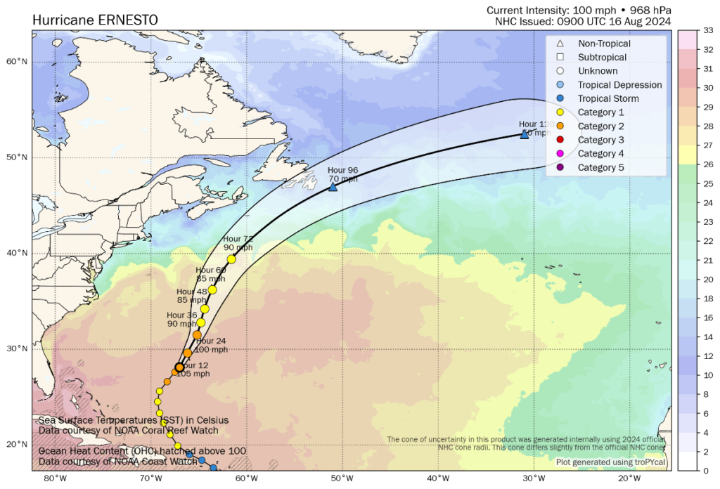
The latest update from the NHC states, “The center of Hurricane Ernesto was located near latitude 28.9 North, longitude 66.5 West. Ernesto is moving toward the north-northeast near 13 mph (20 km/h). This general motion is expected to continue today followed by a slower north-northeastward motion on Saturday. A faster northeastward motion is expected late in the weekend. On the forecast track, the center of Ernesto is expected to pass near or over Bermuda on Saturday.
“Maximum sustained winds are near 100 mph (155 km/h) with higher gusts. Some strengthening is forecast during the next day or so, and Ernesto is forecast to be a large hurricane near Bermuda on Saturday and maintain hurricane strength through the weekend.
“Ernesto is a large tropical cyclone. Hurricane-force winds extend outward up to 70 miles (110 km) from the center and
tropical-storm-force winds extend outward up to 265 miles (425 km).
“The estimated minimum central pressure is 968 mb (28.59 inches).”
You can see hurricane Ernesto’s location, forecast path and intensity, in the graphic below from Tomer Burg:
While hurricane Ernesto is forecast to strengthen a little more, it has struggled for longer than anticipated with dry air entrainment that has slowed its intensification over the last day or two, which may have saved Bermuda from a more impactful event.
It is to be hoped that pattern persists and Ernesto fails to gain much more in the way of intensity before making its closest pass to Bermuda.
But, the large size of the storm, with hurricane force winds said to extend outwards 70 miles from the center, mean any close passage by the island will result in potentially damaging winds.
Bermuda is well-protected by its reef, which can lessen the impacts from storm surge and large waves, but should Ernesto near Bermuda with a rising or high tide (which is due Saturday morning) there still could be some coastal flood effects.
Bermuda’s building codes and preparedness should help the island weather this storm, but power outages are likely, along with downed trees and some structural damage possible.
As we said before, businesses in the insurance, reinsurance and ILS industry began their contingency preparations well in advance of hurricane Ernesto’s approach and many offices are now closed until the storm has passed. Bermuda has weathered worse hurricanes before and is expected to cope well again.
We hope everyone in Bermuda stays safe as Ernesto passes and we expect to see business as usual quickly resurfacing next week.
You can track this and every Atlantic hurricane season development using the tracking map and information on our dedicated page.