Hurricane Beryl nears Yucatan at Cat 3. No risk to Mexico cat bond, Texas in forecast cone
Hurricane Beryl continues to defy the models to a degree, having failed to weaken as much as had been anticipated and strengthened faster through almost its entire life so far, once again the hurricane has intensified back to major Category 3 strength as it approaches landfall on Mexico’s Yucatan peninsula.
A few days ago, the forecasts were calling for Beryl to be a weakening Category 1 hurricane at landfall on Mexico’s Yucatan Caribbean coast.
But, the models have steadily intensified their forecasts and Beryl has also shifted track a little north, with it now set for landfall somewhere along the coast in the region of Tulum, Quintana Roo.
The weakening expected has not occurred and in fact overnight what was a Category 2 hurricane Beryl has intensified again to Category 3, with winds of 115 mph.
Hurricane Beryl’s minimum central pressure had risen to 974mb by midnight UTC time, but then the NHC put out an update cutting 12mb off that and said Beryl had re-intensified to Category 3 with minimum central pressure of 962mb at the time.
At the latest update, hurricane Beryl’s minimum central pressure is pegged back up at 971mb after a reconnaissance aircraft mission, which is expected to rise a little further by landfall in a few hours time.
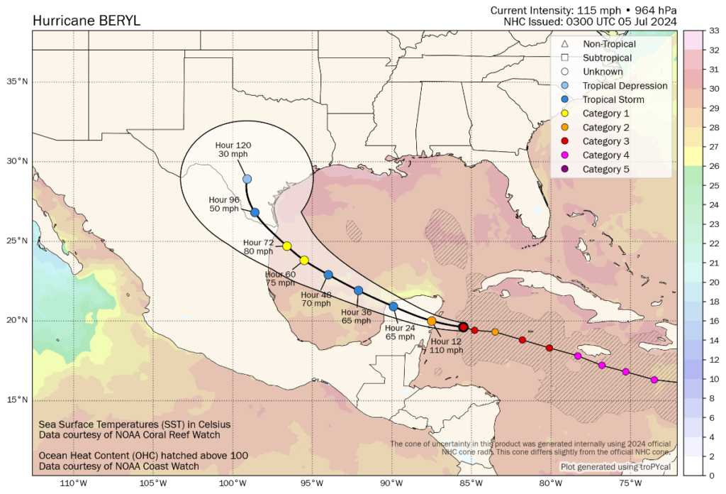
Update: It’s worth noting that the latest forecast update from the NHC has shifted the path for Beryl sufficiently to show a Texas landfall very near to the border, at mid-Category 1 hurricane strength.
You can see the latest forecast and position from Tomer Burg’s map below (click for the latest version):
The entire coastline from south of Tulum up to Cozumel and as far north as Cancun is facing hurricane and tropical storm force winds, but hurricane Beryl’s core has tightened, with hurricane winds now only extending outwards 30 miles from the center, tropical storm force winds extending 140 miles out.
Winds will be most damaging where Beryl’s eye comes ashore, but storm surge is also set to be an issue with heights of up to 6 feet expected as well as rainfall of up to 10 inches.
As a reminder, Mexico has a World Bank facilitated catastrophe bond in-force, which it renewed in April.
Mexico’s government secured $125 million of cover from the Class C notes issued with the IBRD CAR Mexico 2024 cat bond issuance, which is the layer of protection exposed to hurricane Beryl.
This parametric catastrophe bond features a trigger design that has zones along the Atlantic coastline and depending on where a hurricane comes ashore, it must have a central pressure low enough to breach that particular trigger zone and activate the insurance coverage for Mexico.
But, the central pressure needs to be 950mb or lower for Mexico’s IBRD parametric cat bond to face even a 25% loss of principal and in the region of the Yucatan where hurricane Beryl is heading, we’re told it would actually need to be lower still, below 935mb it seems.
So, even though hurricane Beryl intensified back to Category 3 strength and its central pressure dropped somewhat, it is still far too high for Mexico’s parametric catastrophe bond to be threatened.
It’s worth noting though, that Mexico’s tourism industry has been a purchaser of parametric insurance over the years, with some resort owners buying hurricane protection in parametric form.
So, there is the potential for some parametric exposure along Mexico’s Yucatan coastline, being an area with high levels of tourism and many expensive resorts.
Beyond that, the broader insurance and reinsurance market exposure from hurricanes on Mexico’s Atlantic coastline is not typically thought to be significant, with losses typically within reinsurance risk appetites from storms that impact the region.
But, for the people of the Yucatan in the path of major hurricane Beryl, a challenging few hours are ahead and all thoughts are for people’s safety as the storm passes.
Further ahead, hurricane Beryl is set to weaken over the Yucatan and the emerge into the Gulf of Mexico, where uncertainty is the name of the game once again.
Forecast models differ still, with some pointing to a north Mexico landfall as a strong tropical storm or weak hurricane, others opting for the Mexico-Texas border region and a weakish hurricane, but still other forecast models are further north and east, with a stronger hurricane landfall forecast for Texas’ Gulf Coast.
While the model mean aims for the border region right now, meteorologists have been discussing a northward shift and the potential for that to continue, bringing hurricane Beryl further into Texas. There has also been some talk about a potential stalling and turn on approach, which could mean impacts on the Texas coast for longer and torrential rainfall.
It’s worth noting that the latest forecast update from the NHC has shifted the path for Beryl sufficiently north and east to show a Texas landfall very near to the border, at mid-Category 1 hurricane strength, as of 09:00 UTC Friday morning.
With the Gulf of Mexico plenty warm enough to sustain and intensify a hurricane, how long hurricane Beryl spends over it and what track it takes is critical to the eventual strength and landfall outcome.
We likely won’t have a better view of how much of a threat this is to Texas until after Beryl’s passage across the Yucatan, to see whether that severely degrades the storms integrity and hinders its ability to intensify again over the Gulf.
It’s worth looking at another of Tomer Burg’s excellent graphics, which shows the model confidence and spread:
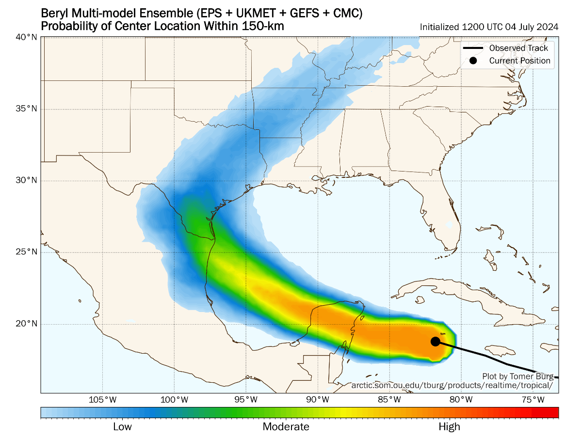
Like the forecast map further up, you can click on the above to get the latest graphic, although it only updates with the main model runs. We’ll also update it as and when we can through the day and this weekend.
Track the 2024 Atlantic tropical storm and hurricane season on our dedicated page and we’ll update you as new information emerges.