Hilary could bring California rare tropical storm conditions, torrential rain

Hurricane Hilary, an east Pacific storm churning off the coast of Mexico with 140 mph sustained winds as a Category 4 major hurricane, is set to approach southern California with tropical characteristics potentially still intact this weekend, signalling a very rare event for the State and region.
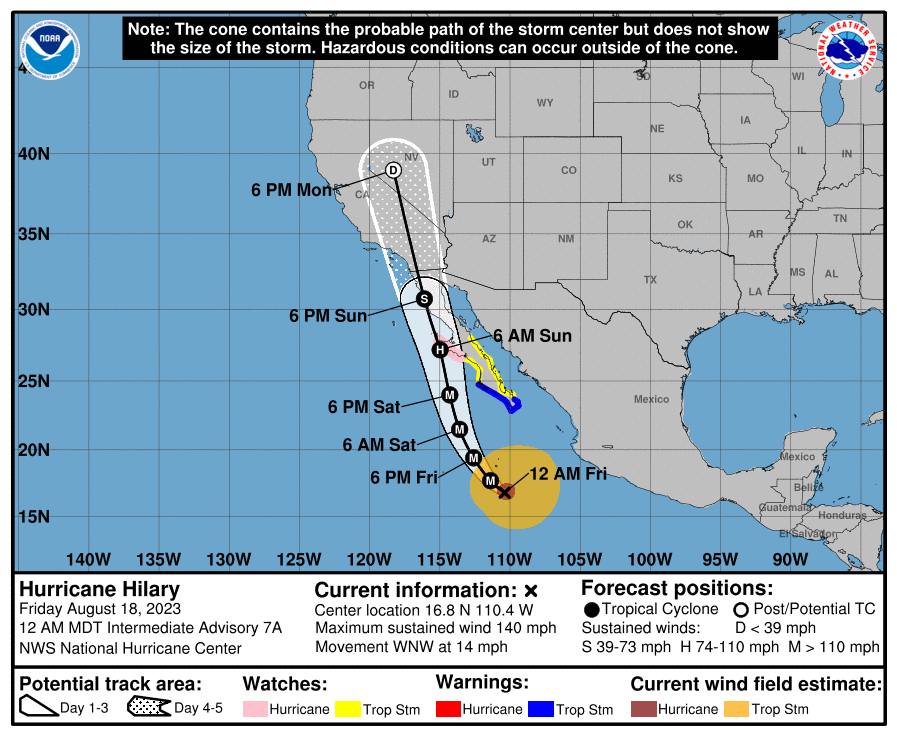
Major Hurricane Hilary is heading west-north-west towards the coast of the Baja peninsula at 14 mph and carrying 140 mph sustained winds, with higher gusts currently.
NOAA says that rapid intensification could continues, as hurricane Hilary traverses warm waters near the Mexican coast, but hurricane Hilary will begin to weaken come Saturday.
What’s particularly interesting about Hilary is the fact it may still have tropical characteristics and bring tropical storm conditions to southern parts of the State of California, which is an extremely rare occurrence.
You can see the latest forecast map for Hilary from NOAA below, which shows the storm transitioning from tropical storm to depression very close to southern California.
Whether Hilary remains a tropical storm, or a depression, it could have tropical cyclone characteristics as it enters southern California and conditions akin to a tropical storm are expected in the region.
In the historical data, a fully tropical system has only passed within 250 miles of Los Angeles once, according to meteorologist Eric Holthaus, and that hurricane, Nora in 1997, also occurred during the first year of a strong El Nino event.
So hurricane Hilary could be an extremely rare event, if it can maintain tropical characteristics. But even if it doesn’t the rainfall and flash flooding threat for parts of California is significant.
NOAA forecasts “3 to 6 inches, with isolated maximum amounts up to 10 inches, across portions of the Baja California Peninsula through Sunday night.” Saying that, “Flash flooding, locally significant, will be possible.”
Further afield, NOAA forecasts, “Rainfall amounts of 3 to 5 inches, with isolated amounts of 10 inches, will be possible across portions of southern California and southern Nevada. Elsewhere across western Arizona, southwest Utah, central Nevada, and central California, rainfall totals of 1 to 3 inches are expected.”
The western Baja California peninsula of Mexico, near where Hilary makes landfall, will experience the worst, with hurricane force winds and a possible storm surge.
NOAA also warns of strong winds for the United States, saying, “The threat of significant wind impacts continues to increase for the northern portions of the Baia California Peninsula and the Southwestern United States, especially in areas of mountainous terrain. Although it is too soon to determine the location and magnitude of these impacts, interests in these areas should monitor the progress of Hilary and updates to the forecast. Watches could be issued for portions of this area on Friday.”
Meteorologists are highlighting the rainfall and flash flood threat as the most significant factors for California, with some typically very dry parts of the State likely to see more than a year’s worth of rainfall, possibly two or more for desert areas, as storm Hilary and its remnants pass.
That could deliver severe flash flooding and associated landslide threats, to some parts of the state.
The most significant impacts from hurricane Hilary are likely to be felt in Mexico, while the storm effects in California and surrounds are likely to be more secondary peril in nature.
But there will be exposure for insurance carriers operating in California, although losses are likely to be at the level that is retained, rather than ceded to now higher-attaching reinsurance, in the main.


