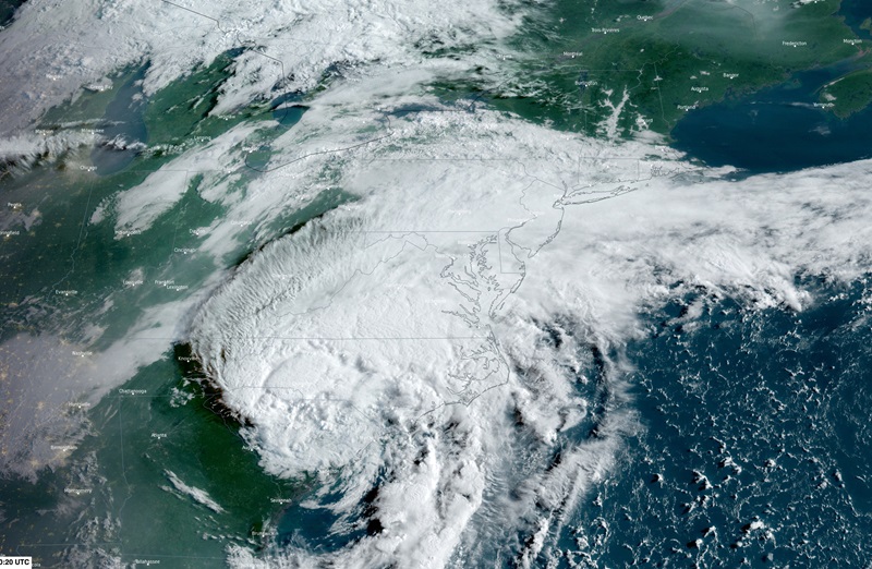
Flash flooding risk in Ontario, Quebec as Debby approaches

MONTREAL, Que. — More than 100 mm of rain is forecast to hit parts of Eastern Canada by the weekend as the remnants of tropical storm Debby make their way to the region.
Environment Canada is warning of heavy rain and risks of flash flooding, water accumulation, and sewer backups across a swath of the country from Cornwall, Ont., to Quebec City. Minor landslides are also a possibility.
Meteorologist Jennifer Smith told a news conference that a low-pressure system over the Great Lakes will bring rain and possible thunderstorms in Eastern Ontario and southern Quebec Thursday night before the weather system merges with what’s left of Debby.
Debby was moving over the Carolinas on Thursday, but was expected to lose its “tropical characteristics” by the time it reaches Canada, Smith said, adding that gusty winds would only likely be felt over the Maritimes when the storm hits that region over the weekend.
“Many regions, particularly a wide corridor from Cornwall to Quebec City, will see rainfall amounts exceeding 50 mm and localized rainfall totals over 100 mm,” Smith said. “As a result, significant impacts may occur in large urban centres such as Ottawa and Montreal, and possibly even Toronto.”
Smith says Montreal receives an average of 94 mm of rain for August, but the city is expected to see 60 to 80 mm of rain on Friday alone.
On Saturday, the weather system will move northeast across eastern Quebec and northwest New Brunswick, then on to northern Newfoundland and southern Labrador on Sunday.
“Gusty winds near 40 to 70 kilometres per hour are possible across the Maritimes, Newfoundland and surrounding water bodies, but wind concerns are expected to remain low and below warning criteria,” Smith said.
Parts of Eastern Canada have received “abundant” periods of heavy rain so far this season, Smith said, which has left the soil saturated with a reduced ability to absorb water.
She urged Canadians to pay attention to forecast warnings and delay plans, if possible, in order to avoid venturing out into the rain. However, she does not expect anywhere near the same kind of havoc that Debby has wreaked on the United States, where the storm has so far killed seven people.
Research scientist Nathan Gillett says climate change appears to be leading to a rise in the number of intense rainfall events as the atmosphere grows warmer and holds more moisture.
“In general terms, on the North American scale, on the global scale, we are seeing an intensification of the heaviest precipitation events and that intensification is projected to increase in the future,” Gillett said.
This report by The Canadian Press was first published Aug. 8, 2024.
—With files from The Associated Press
Photo Credit: Environment and Climate Change Canada is warning about the impacts of heavy rainfall in eastern Canada over the next few days as the remnants of tropical storm Debby merge with an existing-low pressure system tracking eastward into Atlantic Canada from the Great Lakes. This satellite image provided by CSU/CIRA-NOAA shows tropical storm Debby over the U.S. East Coast on Thursday, Aug. 8, 2024 at 8:10 a.m. EDT. THE CANADIAN PRESS/HO-CSU/CIRA-NOAA


