Idalia landfall at Cat 3 125mph winds, to impact Florida, Georgia, Carolinas

Major hurricane Idalia has made landfall on the Florida Big Bend with winds around 125 mph near Keaton Beach at 7.45am EDT and now major hurricane impacts will spread through the landfall region of Florida, while hurricane and tropical storm impacts can be expected more widely and into Georgia and the Carolinas as well.
Hurricane Idalia will have wide-reaching effects, although we understand the insurance, reinsurance and insurance-linked securities (ILS) markets are working off an expectation that the industry loss will be in the single digit billions of dollars with this storm.
As a result, the majority of the loss is expected to be retained in the primary insurance market, with some exposure to certain reinsurance layers and perhaps some ILS funds with collateralized participations.
The catastrophe bond market is likely to escape any direct loss if the industry impact remains in single-digit billions of dollars, it seems, although some erosion of aggregate deductibles is possible, as with any significant catastrophe loss events.
Storm surge will now be a significant issue for coastal areas, while hurricane force winds are expected to batter parts of Florida and move into Georgia as well.
In fact, the NHC has warned that there is a chance South Carolina also experiences hurricane force winds with Idalia, so the footprint of the storm could be significant.
Meanwhile, rainfall will also be an issue, with storm totals into the double digit inches expected.
Hurricane Idalia underwent an eyewall replacement cycle just before landfall, which seems to have moderated its winds somewhat and some meteorologists were discussing dry air entraining into the eye of the storm, which also hindered its ability to intensify right up to landfall.
But still, hurricane Idalia is a major category 3 storm landfall for the Florida coast, bringing significant danger to lives and livelihoods.
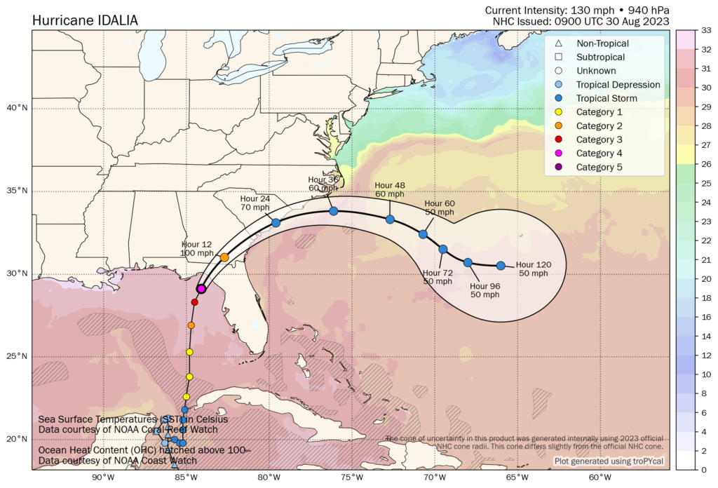
You can see the latest location for Idalia below, using Tomer Burg’s excellent map which shows wind speed forecasts in increments and sea surface temperatures as well, using the NHC data:
The map above also shows, at this time, that 100 mph winds are seen as possible for Georgia, with Cat 1 hurricane winds possible for South Carolina as well.
Reinsurance broker Gallagher Re said earlier that the industry loss from hurricane Idalia could be in the low single digit billions of dollars.
Our sources are suggesting we will see an insurance and reinsurance market loss somewhere from the mid single digit billions of dollars upwards, but remaining sub $10 billion, incorporating all impacts from the storm outside of Florida as well.
There is still some uncertainty there, with the situation developing and hurricane Idalia only just coming ashore.
Landfall location is critical in minimising the industry loss here, with Idalia having come ashore in a relatively low populated area of Florida coastline, as too is the relatively compact size of the storm given Idalia’s hurricane strength winds only extend out 25 miles from the center.
It will take some time for the industry loss to become clear though, but we expect some modelling firms may provide initial estimates within the next day and we will update you.
The NHC’s latest update states, ” Idalia is a category 3 hurricane on the Saffir-Simpson Hurricane Wind Scale. Although Idalia will weaken further now that the center is inland, it is likely to still be a hurricane while moving across southern Georgia, and near the coast of Georgia or southern South Carolina late today. Idalia is forecast
to be a tropical storm while moving near the coasts of northeastern South Carolina and North Carolina tonight and on Thursday.”
Track storm or hurricane Idalia and the entire 2023 Atlantic tropical storm and hurricane season on our dedicated page and we’ll update you as new information emerges.


