Hurricane Helene forecast for major Florida Big Bend landfall, with deadly storm surge, winds far inland
Hurricane Helene is in the Gulf of Mexico and having wrapped convection around itself looks set for rapid intensification over the day as it speeds towards what is still expected to be a Big Bend, Florida landfall. Intensity forecasts are now somewhat higher, as too are the forecasts for a deadly storm surge and for Helene’s winds to impact further inland.
Most everything we said in our update yesterday on hurricane Helene still stands, the storm remains set on tracking into the less populated Big Bend region of the Florida Panhandle, but still any deviation or wobbles in the track could raise the eventual cost to insurance, reinsurance and potentially insurance-linked securities (ILS) markets.
Helene is expected to grow to a very large size as it intensifies towards Category 3 or higher major hurricane status today.
That means wide-reaching impacts and a storm that any wobble in forward path could bring greater impacts to regions of higher population and greater insured value exposure.
Hurricane Helene is also expected to be fast moving, with the potential for its hurricane force winds to reach far inland and the NHC has hurricane and tropical storm warnings extending right into the southeast US as a result.
Still, the insurance and reinsurance market loss is being estimated in the single digit billions of dollars, with a higher double-digit figure deemed possible should the city of Tallahassee take a hit from the strongest winds as hurricane Helene comes inland, or if the storm wobbles east and stronger winds and higher storm surge extend down towards Tampa Bay.
The consensus of the forecast models continues to be for the Big Bend landfall scenario, under which the single digit billion insurance industry loss still seems the most likely outcome.
As we said yesterday, model runs showing much higher figures continue to be shared, although the eye-watering modelled loss scenarios for a nearer Tampa landfall are not as prevalent from our sources this morning.
As we reported yesterday afternoon, if the Big Bend landfall scenario is the eventual outcome for hurricane Helene, impacts to the catastrophe bond are expected to be minimal, despite the intensity expected from the storm.
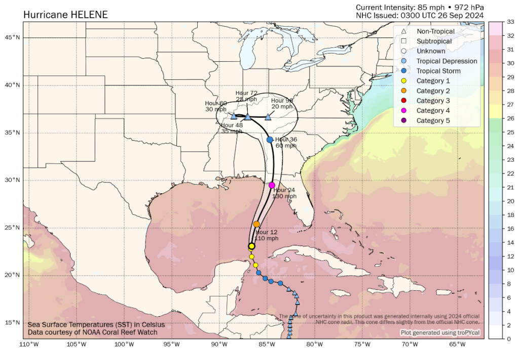
You can see the latest forecast path, cone and intensity for hurricane Helene in the graphic below from Tomer Burg:
Most striking overnight is that top-end intensity estimates for hurricane Helene have risen again, with now just over 130 mph sustained winds forecast for landfall by the NHC, with gusts higher still at over 160 mph.
Given also that Helene has continued to expand in size as well, the forecasts for storm surge have risen and now for the Big Bend region from Carrabelle, FL to Suwannee River, FL up to 20 feet is now anticipated, which is generally considered not survivable and so the need to evacuate that region is clear.
The NHC said in its latest update, “At 400 AM CDT (0900 UTC), the center of Hurricane Helene was located near latitude 24.2 North, longitude 86.2 West. Helene is moving toward the north-northeast near 12 mph (19 km/h). This general motion is expected to continued with a significant increase in forward speed during the next 24 hours. On the forecast track, Helene will move across the eastern Gulf of Mexico today and cross the Florida Big Bend coast this evening or early Friday morning. After landfall, Helene is expected to turn northwestward and slow down over the Tennessee Valley on Friday and Saturday.
Maximum sustained winds have increased to near 90 mph (150 km/h) with higher gusts. Strengthening is forecast, and Helene is expected to be a major hurricane when it reaches the Florida Big Bend coast this evening. Weakening is expected after landfall, but Helene’s fast forward speed will allow strong, damaging winds, especially in gusts, to penetrate well inland across the southeastern United States, including over the higher terrain of the southern Appalachians.
Hurricane-force winds extend outward up to 60 miles (95 km) from the center and tropical-storm-force winds extend outward up to 345 miles (555 km). The Key West Naval Air Station recently reported sustained winds of 41 mph (66 km/h) and a wind gust of 64 mph (103 km/h).
The estimated minimum central pressure based on Air Force Reserve Hurricane Hunter aircraft data is 966 mb (28.53 inches).”
It’s worth noting that since this article first went out this morning the NHC has slightly reduced its wind speed forecasts for landfall, back to Category 3 of around 115 mph. But with rapid intensification up to landfall possible, Cat 4 is still possible it seems.
The NHC said, “The new intensity forecast calls for Helen to become a major hurricane in about 12 h, and additional
intensification is expected in the ensuing 6 h period or so before landfall.”
But it did also note that “Helene is sending some mixed structural signals this morning” which appears to have resulted in the slight downgrading of wind intensity forecasts for landfall at this time. This could change though and rapid intensification all the way to the Big Bend coast of Florida is possible.
The inland impacts should not be underestimated and if Helene comes close to higher value areas of exposure, such as Tallahassee it will have commensurate implications for the eventual insurance market loss.
Some models suggest hurricane speed wind gusts right into Georgia and even beyond, which alongside a forecast for widespread 6 to 12 inches of rainfall with isolated totals around 18 inches, should again not be underestimated for its impacts.
Tampa Bay is still seen as being less impacted, with storm surge forecasts remaining at up to 8 feet. Again, any jog east in the track of hurricane Helene could raise those figures and if the storm gets closer to the Florida Peninsula west coast there remains the potential for a much higher industry loss.
Hurricane Helene is set to present a significant threat to lives, property and assets in its path, as a result of which the track the storm takes, how far inland the winds sustain stronger speeds, as well as broader impacts from surge and rains, all mean location remains everything for this storm.
As a result, insurance, reinsurance, catastrophe bond and ILS market interests will watch very closely throughout today, as still any deviation from the forecast path could change the industry impact considerably.
Finally, Andrew Siffert, Senior Meteorologist at BMS Group, said in his latest update, “It is still too early to provide loss estimates for the insurance industry, as a shift in the storm’s path closer to Tallahassee could significantly raise the overall losses. There are still questions as to the overall size of the wind swath and how it might impact the west coast of Florida. In general, however, given the rural nature of much of the Florida landfall area and areas into southern Georgia, it should provide a lower loss than what was experienced in Hurricane Michael in 2018 ($16B), which had a track west of Helene as a category five hurricane with strong winds up into southern Georgia. We have to remember that Idalia made landfall in the same general area last year as a major hurricane, and according to the catastrophe risk model, this was one of the strongest hurricanes to make landfall to have such a low level of loss and that was partly to rural nature of the landfall areas. Helene will likely fall into the same category: powerful hurricane but with reasonably low insurance industry loss.”
You can track this and every Atlantic hurricane season development using the tracking map and information on our dedicated page.