Forecasters monitoring Ernesto’s track towards Canada
Less than a week after the remnants of Hurricane Debby dropped between 100 mm and 200 mm of rain on Quebec and eastern Ontario, the Canadian Hurricane Centre is showing Tropical Storm Ernesto tracking towards Atlantic Canada.
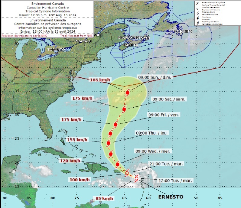
“Ernesto will strengthen in the Atlantic Ocean, likely developing into the third hurricane of the 2024 hurricane season by the end of the week,” The Weather Network predicts.
“While it’s still far too early to say, some long-range models do suggest that Ernesto could pass near enough to the Canadian East Coast to bring heavy rainfall early to mid next week,” The Weather Network reports. “Most models do have the storm recurving out to sea before reaching Atlantic Canada. Regardless, this storm will certainly be one to watch this week…”
Currently a tropical storm, Ernesto is expected to dump heavy rainfall over parts of the Leeward Islands today and spread westward to the Virgin Islands and Puerto Rico later today and tonight, according to the U.S. National Hurricane Center.
“Tropical Storm Ernesto is expected to produce total rain accumulations of four to six inches [160 mm to 240 mm] over portions of the Leeward Islands, from Guadeloupe to Dominica and across the U.S and British Virgin Islands,” the U.S. National Hurricane Center reports. “Rainfall totals of six to eight inches [240 mm to 320 mm], with maximum amounts of 10 inches [400 mm], are expected across southeastern Puerto Rico, with totals of two to four inches [80 mm to 160 mm] across northwestern Puerto Rico.
“Hurricane conditions are also possible on the Virgin Islands, Culebra, and Vieques this evening and tonight.”
In other news: Will Calgary hailstorm rival 2020’s $1.2 billion event?
Ernesto’s heavy rainfall may result in “considerable flash flooding and mudslides” in local areas of the Leeward Islands and over the Virgin Islands into Puerto Rico through Wednesday, the National Hurricane Center reports.
Upon reaching Bermuda, Ernesto’s track bends northwards, and the Canadian Hurricane Centre’s track shows the storm heading towards Atlantic Canada.
Meanwhile, Quebec is still drying out after being hit with between 90 mm to 200 mm of rain connected to Tropical Storm Debby.
Torrential rainstorms on Friday drenched Montreal in 145 mm of rain, surpassing the previous daily rainfall record set nearly 30 years ago, according to Environment Canada.
Some communities along the St. Lawrence received between 100 mm to 211 mm of water.
The rains caused flash flooding affecting 35 municipalities across the province. In addition to shutting down the Dorval tunnel on Highway 13, floods affected nearly 100 roads, damaged buildings and vehicles, and caused 344 people to be evacuated from their homes, Quebec’s public security minister reported.
There were 1,539 isolated residences affected by flooding, the Quebec government confirmed.
With files from Alyssa Di Sabatino
Feature image courtesy of Environment Canada: Canadian Hurricane Centre